Areas of Operation in Malkangiri District
State: Odisha
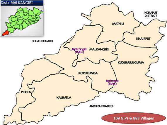
District : Malkangiri
Peoples’ Organisation (Jan Sangathan)
Shramjeebi Sanghtan (SS)
& Mahila Shramjeebi Sangthan(MSS)
Malkangiri District Map
Distirct Profile
Malkangiri district is almost a vast dense jungle, with a very small percentage of the population residing in the urban areas. The district is divided into two distinct physical divisions. The eastern part is covered with steep ghats, platues and valleys, sparsely inhabited by primitive tribes. The cliamate in the district is generally cold during winter and hot in summer.Relative humidity is generally high, especially in the monsoon and post-monsoon months. During the rainy season, most areas of the district become impassably swampy and heavy floods isolate it from the outer world. This district lies within the malaria prone belt. This district is one of the most underdeveloped districts. The schedule tribe population is 57.43%. The largest thwo tribes are Koya and Bhumiya. It is also home to the primitive Bondas, Porajas and Didayis.
Atmashakti Intervention: June 2011
| ADMINISTRATIVE SETUP | |
| Area | 5,791 sq km |
| Blocks | 7 |
| Panchayats | 111 |
| Villages | 1,045 |
| Rural/Urban | 91.97/8.02 |
| DEMOGRAPHY | |
| Population | 6,13,192 |
| Sex Ratio (females 1000 per males) | 1016 |
| Children (0 – 6 years) | 1,09,092 |
| Average Family Size | 5.00 |
| No of Aganwadis Centres/ Mini AWC’s | |
| No of Primary Health Centres/ Sub Centre | 24/158 |
| Infant Mortality Rate | |
| Maternal Mortality Rate | |
| Literacy | 49.49 |
| ECONOMY | |
| HDI | 0.370 |
| GDP | 0 |
| Per capita Income Rs | |
| Per capita-state | 5,200 |
| Forest Cover | 3355.88 sq km |
| Industrial units | none |
| Irrigated Area | 2940 hectares |
| Affected by Left Wing Extremism | YES, Severerly |
| MGNREGA DATA (2020-21) | |
| No. of Families who got work | 61218 |
| Average No. of Days | 54.99 |