Areas of Operation in Nuapada District
State: Odisha
District : Nuapada
Peoples Organisation (Shramjeebee Vikas Manch)
Nuapada District Map
District Profile:
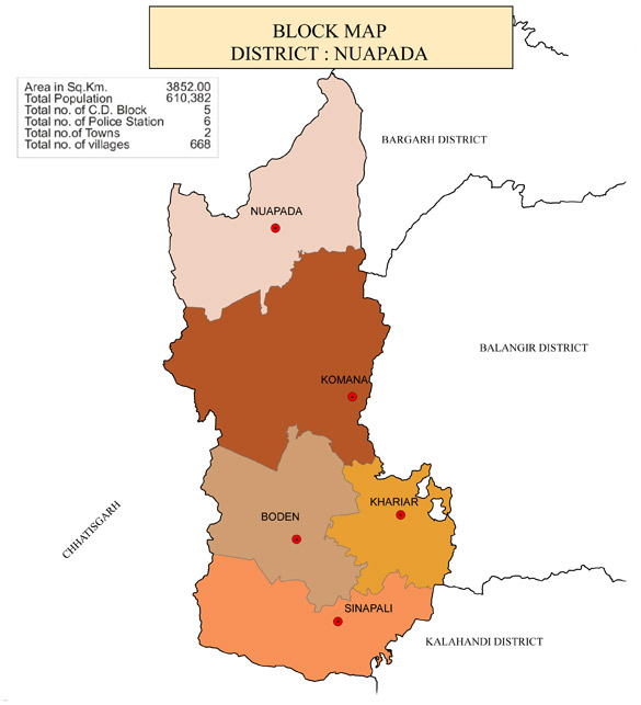
Nuapada District was created on 1st April 1993 by carving out of undivided Kalahandi District with an area of 3408 Sq. Present Nuapada District comprises one sub-division (Nuapada), five Tahsils (Nuapada, Khariar, Komna, Boden and Sinapali) and five Blocks (Khariar, Sinapalli, Boden, Nuapada and Komna).
They contain mineral deposits such as laterite, graphite and bauxite. The hill sides rising up precipitously from the plains are covered with dense sal forests. The forests of the District are managed under Forest Division named as Khariar Division. According to the composition of forests in the District, it can be classified into Sal forests, Teak forests, miscellaneous forests. There are other forest species such as Teak and Bamboo. All these are situated in the dry deciduous forest zone. Timber is by far the major forest products and Sal is no doubt, a major constituent of these products. Other important species of Nuapada forests are Bija, Asan, Bandhan.
There are some other minor forest produces of this region which include Kendu leaf, Broom-grass, Mohua flower and Its seed, Antia bark and Sabai-grass. Timber, Bamboo and kendu leaf are the major produces which are exported outside of the state.
Atmashakti started its intervention in November, 2016 with Sharamjeebi Vikas Manch.
| NUAPADA DISTRICT PROFILE | |
| ADMINISTRATIVE SETUP | |
| Area | 3852 sq.km |
| Blocks | 5 |
| Tahasils | 5 |
| Gram Panchayats | 131 |
| Villages/ Revenue Villages | 652/670 |
| Rural/Urban Ratio | 94.42/5.58 |
| DEMOGRAPHY | |
| Population | 610,382 |
| Sex Ratio | 1,021 |
| Children (age 0 to 6 years) | 88344 |
| Average Family Size | 4 persons |
| No of Aganwadi’s Centre / Mini AWC’s | |
| No of Primary Health Centers / Sub centers | 17/1 |
| Infant Mortality Rate | 52 |
| Maternal Moterality rate | 31 |
| Literacy | 57.35 |
| ECONOMY | |
| HDI | 0.19 |
| GDP | 17.58 |
| Per capita Income Rs | |
| Forest Cover | 1849.00 sq. km |
| Industrial Units | Rice mills, Terracotta, cotton and agriculture and Non-timber-F |
| Irrigated Area | 189170 hect |
| Affected by Left Wing Extremism | No affected |
| MGNREGA DATA (2020-21) | |
| No. of Families who got work | 54019 |
| Average No. of Days | 64.86 |