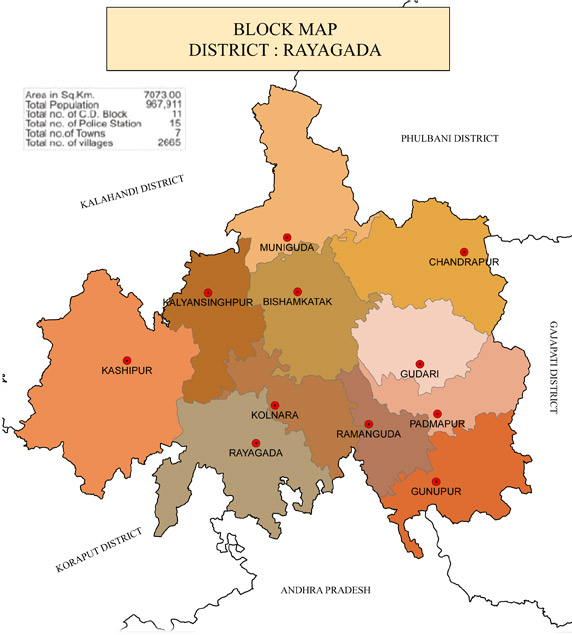
Areas of Operation in Rayagada District
State: Odisha
District: Rayagada
Peoples Organisation (Jan Jagarana Manch)
Rayagada District Map

District Profile:
Rayagada district is known as the most famous region of the state because of its longest human history. Although the district came into existence on 2nd October 1992, it has long and glorious historical records evident by copper plates, rock inscriptions as well as different coins, which clearly indicate that the region was the centre of attraction in all ages. A subsequent literature found at Pataleswar temple speaks about the River Languli giving a supporting evidence to the various facts.
Rayagada is a district of meadows, forests, waterfalls and terraced valleys, peopled by many primitive tribal groups. The scenic beauty and heritage on the land is an unexplored paradise.
The pattern of people living in the district show unity in diversity of races, languages, and culture. The Scheduled Tribes living in the district possess dissimilar economics ranging from food gathering to settled cultivation. Their languages/dialects, societies and culture show inter-societal and -cultural variations because of the ethnic mosaic.
Atmashakti began its intervention in the area in Sept, 2016.
| RAYAGADA DISTRICT PROFILE | |
| ADMINISTRATIVE SETUP | |
| Area | 7073 sq.km |
| Blocks | 11 |
| Tahasils | 11 |
| Gram Panchayats | 182 |
| Villages | 2,667 |
| Rural/Urban Ratio | 84.82/15.18 |
| DEMOGRAPHY | |
| Population | 967,911 |
| Sex Ratio | 1,051 |
| Children (age 0 to 6 years) | 1,48,522 |
| Average Family Size | 4 person |
| No of Aganwadi’s Centre / Mini AWC’s | 103 |
| No of Primary Health Centres | 36 |
| Infant Mortality Rate Per 1000 | 33 |
| Maternal Moterality rate Per Lakh | 170 |
| Literacy | 64% |
| ECONOMY | |
| HDI | 0.18 |
| GDP | |
| Per capita Income Rs | |
| Forest Cover | 777.27 sq.km |
| Industrial Units | Aluminium Steel Plant, Metal |
| Irrigated Area | 48559 |
| Affected by Left Wing Extremism | yes, high |
| MGNREGA DATA (2020-21) | |
| No. of Families who got work | 67735 |
| Average No. of Days | 60.21 |
